This has been a long requested feature. Still working through bugs, but it’s stating to come together. For a given target, if you have a user profile with valid latitude and longitude (setting this in your mount’s ASCOM driver is not sufficient) and a valid target position in the target settings dialog (RA, DEC), then certain altitude controls will be available. With them, you can:
Set target start and end times, as normal, and see what altitude those times correspond to
Set target start and stop altitudes and see what times those altitudes correspond with
View errors and warning associated with those settings
View the target’s next transit (+/- 5 min… not great for science, but likely good enough for SGPro)
View a graph that shows the target altitude, over time
The green dot shows start time / altitude
The red X graph shows end time / altitude
The vertical blue line is “now”
The shaded green area shows the time frame for which this target is allowed to capture
As is normal with stuff like this, the UI and error handling take 95% of the time.
Note 1: Because it will likely be the first question asked… This interface does not currently support setting target start / end times / altitudes, but that is coming! The end goal will be to allow you to click on the graph to set those times… right now it is informational.
Note 2: Want to see all your targets on one graph so you can pick the best start / end times for each? That would be pretty cool and also adds considerable difficulty. We have this on the radar though.
I think it turned out OK. We had to go ahead and implement start/ end time selection by clicking the graph because it seemed like the best solution to decoding user intent. If you enter an altitude, SGPro does not which side of the meridian you mean (we could add E / W stuff, but the graph seems more elegant). You can adjust target start / end times by using the numeric and date controls (even while the graph is open) or you can click the graph. It’s pretty flexible and, with it, you can:
Set target start and end times (from target settings), as normal, and see what altitude those times correspond to. This does not need the new visual aids. It works just by updating the times in the form.
Set target start and stop altitudes and see what times those altitudes correspond with. This does not need the new visual aids. It works just by updating the altitudes in the form.
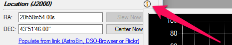
With the new visual aids, click on the “i” next to the “Location” section, you can:
View target ephemeris graph showing the target altitude, over time
View capture time markers:
The green dot shows start time / altitude
The red X graph shows end time / altitude
The vertical white line is “now”
The shaded green area shows the time frame for which this target is allowed to capture
You can now left click on the graph to select a new target start time
Right click on the graph to select a new target end time
View errors and warning associated with current settings
No lat / long set error
Target has an invalid location error
Desired altitude is below the horizon warning
Desired altitude is low warning
View the target’s next transit time and altitude (+/- 2 min)
Looks cool! One question: For those of us who spend weeks or months on
the same object, can we set the altitudes once or would we need to do it
every night? In other words, if I choose 35 degrees, does it figure out
the right time when I hit run night after night?
Sorry, I hit Reply too soon and missed part of the message.
How will one get this graph to display?
If I am understanding this correctly, the graph is basically doing an altitude to time conversion and the time constraint is really what SGP is using. The problem I have with this method is the altitude to time conversion is only valid for one date so if I use a sequence more that one night I have to redo it each night.
The graph is a cool feature, however, I hope the user can directly enter altitude constraints rather than having to always use the graph. For example, as a rule, I try to get targets above 45 degrees for imaging. So I would like to enter that constraint directly. I can already determine the targets path via other means but I can’t constrain the capture altitude in SGP currently.
Nothing has changed in SGPro’s current core functionality. SGPro will continue reapply start / end times night after night without user intervention. The issue with this approach is not that you need to continually reapply the start and end times (this will happen automatically) it’s that, in it’s current form, SGPro does not know whether or not to lock time or altitude. Right now, time is locked, so night after night, your altitude will change. We will address this in one way or another in the near future… not sure exactly what the interface will look like just yet.
No, just the opposite right now, it keeps the time constant and adjusts the altitude (as described above). Locking either one in place is a valid approach, there is just no interface to support it yet. Maybe we will put little lock icons next to the form fields or something.
By clicking here:
True, see above. That said, it is no more limiting than SGPro in it’s current form. We don’t know which you will want to lock and will need to modify the UI in order to ascertain.
To each his own. The graph is merely a tool. It is, in no way, required to use time / altitude features. You can enter by hand or use the graph to select… you can even enter by hand when the graph is open.
It seems to me an altitude constraint is just one value where you want the altitude greater than that value. If you added a single line with a checkbox and altitude value below the current time constraint, I think that would be all that you need. Like the time constraint I think the logic between the fields should be AND. So the user could choose which constraints to apply with the checkboxes (i.e. one or two time values and one altitude value) Of course, one could get fancier and have two altitude fields one east and one west (or leading and following values). Again, it would be AND logic. I suspect one altitude field would serve for most people.
If you already have the altitude calculations, adding the UI and logic should straight forward.
That’s a nice UI, it should be pretty clear what people are getting.
BTW could the predicted times it gets dark and light be added? Maybe a pale blue band for daylight, ideally shading for twilight.
When using the altitude start / altitude stop feature, you really want the altitudes to stay constant and the actual start / stop times to automatically update each night. Perhaps, when initially loading a sequence file, SGP would see that one or more targets were using the altitude parameters and automatically update the start / stop times. By the time I am able to open the Target Settings dialog box, the times have already been updated for me to see. Having altitude parameters of 0 indicates that feature is not being used. Needing to tell SGP to update the start / stop times, is something I will always forget to do.
i agree that while this feature is good for target planning, in my mind the whole point was to automagically change the start and end times as the year goes on. hopefully that functionality will come to this feature soon.
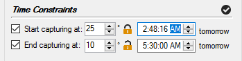
Alright, based on feedback I have implemented this now in order to avoid public shame.
On that target, SGPro will start the target, night after night, at 25 degrees (altitude lock) and will end every morning at 5:30 AM (time locked). Clicking the locks will toggle the lock state.
I agree that you want this available, just not that it is always desired (see example above where a time lock is preferred).
Yes, I like this idea. After the first beta goes out I can play around with some visuals and try to produce something that is not too garish.
I currently bounce back and forth between the sky map in SkyTools 3 and SGP to decide when to start and stop my imaging. An enhancement to think about for the future - the ability to define my local horizon (tied to user profile) and show its impact via the graph. SkyTools 3 does this by dimming the line if the target is below my local horizon (trees, house, etc.).
E.g. right now I’m imaging the Trifid and it’s only visible for about an hour between two trees, so I have to pick my start and end times very carefully!
I would also support that. My roll-off roof obscures much of my Western sky when it is open (not an issue because that is where my skyglow is anyway). It would be nice to know exactly when it is going behind the roof, once in a while I guess wrong and lose the object and have the sequence abort. Not often, but it would help.